
Adapted by:
Matías S. Zavia
WriterAerospace and energy industries journalist at Xataka.

Karen Alfaro
WriterCommunications professional with a decade of experience as a copywriter, proofreader, and editor. As a travel and science journalist, I've collaborated with several print and digital outlets around the world. I'm passionate about culture, music, food, history, and innovative technologies.
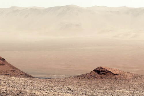
The tireless Curiosity rover just sent back a new video of Mars that is quite simply a gem: A 30-second immersive panorama that transports you to the slopes of Mount Sharp. Watch it in full-screen mode—it’s the closest you’ll get to walking on the red planet until SpaceX CEO Elon Musk sells Starship flights.
A familiar world. At first glance, the images NASA’s rover captured in February might remind you of a desert landscape in Chile or the southwestern U.S. But don’t be fooled—that “mountain range” in the distance marks the edge of the enormous Gale Crater, which an asteroid impact formed billions of years ago.
Curiosity, a rolling laboratory the size of a Mini Cooper, climbed the slopes of Mount Sharp, an imposing 3-mile-high mountain sculpted by time within the crater. Since it arrived in 2012, Curiosity has traveled about 20 miles across the dusty Martian terrain, tirelessly exploring Gale Crater.
What you’re seeing. The rover captured these images in an area formally known as the “sulfate-bearing unit,” which is rich in saline minerals. Scientists believe these minerals are the legacy of streams and ponds that dried up eons ago—before Mars shifted from a potentially Earth-like world to the frozen desert it is today.

NASA invites you to let your imaginations run wild: “You can imagine the quiet, thin wind, or maybe even the waves of a long-gone lake lapping an ancient shore.”
Onward to new mysteries. Although the Curiosity expedition has explored Mars for nearly 13 years, it isn’t stopping here. The rover left the Gediz Vallis channel behind, where it accidentally discovered elemental sulfur about a year ago—a puzzling find, since on Earth, sulfur usually appears near volcanic gases or bacterial activity. It now heads toward a region with intriguing geological formations called “boxwork.”
These structures, visible from the Mars Reconnaissance Orbiter, resemble spider webs with ridges stretching for miles. They likely required warm groundwater to form. And where there’s water, there’s potential to find evidence of past life. Researchers wonder if the “boxwork” could have harbored ancient single-celled microorganisms and sent Curiosity to investigate.
 The Mars Reconnaissance Orbiter probe captured an image of the Curiosity rover from above.
Another point of view. As Curiosity travels these long distances on the Martian surface, the Mars Reconnaissance Orbiter tracks its journey from above. On Feb. 28, the spacecraft’s HiRISE camera captured the first orbital image of the rover in full motion on the red planet.
In the image, Curiosity appears as a dark speck in front of a long trail of tracks stretching about 1,050 feet. These tracks may remain visible for months before Martian winds erase them.
Images | NASA
Related | ESA’s Mars Rover Is Cursed: The ExoMars Mission Has Faced 20 Years of Hardship and Bad Luck