
Adapted by:
Pablo Martínez-Juarez
WriterEnvironmental economist and science journalist. For a few years, I worked as a researcher on the economics of climate change adaptation. Now I write about that and much more.

Karen Alfaro
WriterCommunications professional with a decade of experience as a copywriter, proofreader, and editor. As a travel and science journalist, I've collaborated with several print and digital outlets around the world. I'm passionate about culture, music, food, history, and innovative technologies.
Over the past few decades, the Global Positioning System (GPS) has become integral to everyday life. Once a military technology, GPS now guides people along roads, through forests and oceans, in cities and in mountains—but always with one major limitation: access to the satellites that support navigation devices.
That could change.
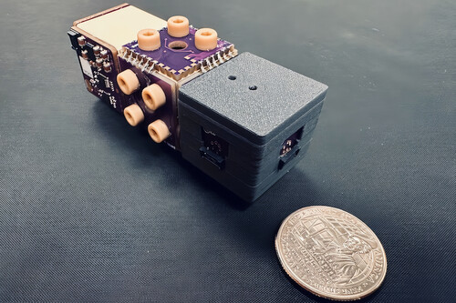
MagNav. Thanks to magnetic navigation systems—also called magnetic anomaly navigation (MagNav)—and more specifically a new development using a quantum tuning system, navigation could soon be more precise. This method is also immune to interference, whether accidental or intentional, significantly reducing dependence on satellite-based systems.
MagNav systems rely on the fact that Earth’s magnetic field is not uniform. It’s possible to use a magnetometer to determine a position by measuring small variations in the planet’s magnetic field.
Using Earth’s magnetic field as a reference is not new. People have done it since the invention of the compass. But this new system promises unprecedented accuracy—and that’s where the quantum dimension comes in.
Quantum navigation? According to its developers, the new technology is based on quantum magnetometers that combine a denoising system with a mapping algorithm. The magnetometers use optical detection of atomic spin precession, employing a vapor cell that contains rubidium atoms.
This approach allows for more precise measurements of Earth’s magnetic field, improving the user’s ability to pinpoint their location. All of this fits in a device small enough for autonomous vehicles or fixed-wing drones.
Q-CTRL. Behind the system is an Australian company called Q-CTRL, short for "quantum control". It was founded in 2017 as a spin-off from the University of Sydney’s quantum science group.
By land and air. The team recently tested the system. Results were promising: The device recorded measurement errors up to 46 times smaller than those from inertial navigation systems typically used as GPS complements.
The tests, conducted at 19,000 feet, achieved a total travel error of 72 feet—just 0.006% of the distance traveled. Results were “consistently” at least 11 times better than those from inertial systems.
The developers have published some details in a paper available on arXiv. While it hasn’t passed peer review, the findings are publicly accessible.

Replacement or augmentation. Satellite navigation is central to modern life—and that’s exactly its vulnerability. Jamming GPS signals threatens commercial routes, passenger transport, and even military operations during conflict. Intercepting these signals can be a weapon—commercial or military.
Several tools can support satellite navigation, but few alternatives can match its accuracy without depending on it. That’s why having high-precision alternatives is more important than ever.
Image | Q-CTRL
Related | Nvidia Eyes Another Disruptive Technology After the Success of Its AI Chips: Quantum Computers